tok-tokkie
Race Dog
In 2009 I posted about the gables on Kerk Straat in Tulbagh. The site I used has since closed. I have linked to that original posting in other threads I have written - so the links lead nowhere now. Additionally the thread got regular casual visitors as it had been picked up elsewhere and linked. I am going to re-post the thread here.
'----------------------------------------------------------------------------------
The VOC authorities did not want the Cape to develop into anything more than a small station to replenish the food & water supplies of their trading ships. Their requirement for meat resulted in expansion of the settlement; the local cattle & sheep herders (khoisan) were reluctant to trade breeding stock. In 1658 a party was sent out from the fort to try and barter for cattle, one of that party got to see the Tulbagh valley (initially known as Roodezand) but it appeared to be uninhabited to him. Forty years later (1699) the next traveller to see the valley was Governor Willem Adriaan van der Stel. It created a very good impression upon him and he arranged for settlers to be sent there in 1700.
This was the beginning of white settlement in the valley. In 1743 a church was built. A parsonage (pastorie) and house for the sexton were also built but there were no other residents around the church – it served the local farmers who had had to travel to Paarl previously for church. Fifty years later in 1794 the church was too small for the local farming community of about 40 families so the church had to be enlarged. To fund this they got a surveyor in who laid out a row of erven along the track from the pastorie to the church. These were offered for sale & the money raised used to pay for the additions to the church. (This became a common practice for church towns thereafter.) In 1803 there were 12 houses on this road.

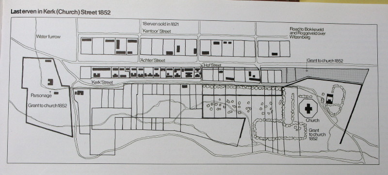
In this picture you see the church on the right and the parsonage (pastorie) on the left with Kerkstraat joining the two. The plan is for about 1852; the town had expanded into another street (Achterstraat) by then. The two houses on the right are not aligned to the street. The twelve houses facing Kerkstraat had gardens running right down to the river – in those days you had to provide your own food & that included the predikant who had quite a decent sized piece of land at the pastorie.
So those houses date from about 1800 and were built of local materials. The authorities built a Drostdy (magistrates Court) in 1804; this was the second one outside Cape Town (Stellenbosch was the first). The British took over control at the Cape in 1806 and one of their Governors founded a new settlement at Worcester in 1818 and built a Drostdy there – but it was a sub-Drostdy to the main one in Tulbagh. In 1822 the Drostdy in Tulbagh was damaged in a violent storm & the Governor used that as a pretext to close it & make Worcester the only Drostdy in the area. This had a stultifying effect on the development of Tulbagh so little happened there and the town was preserved much as it had been. In 1969 there was quite a severe earthquake that badly damaged many of the buildings in the area. Because of its history the layout of the town was very much as it had been though the buildings had been altered over the years. Architect & architect historian Gawie Fagan & Hans Fransen were very aware of the preserved nature of the town & they rushed out there the next day to see what had happened. They quickly realised that with the financial support of Anton Rupert and a specially formed Restoration Committee there was a real possibility of rebuilding Kerkstraat to be a faithful representation of what the buildings had looked like before.
I was very fortunate to have gone there last Saturday with the VERNACS (Vernacular Architecture Society of South Africa = Volksboukundige Vereeniging van Zuid Afrika) and both Hans & Gawie were there. I want to show what the buildings look like now 40 years later.
I will show photos of each building and add a little note about them. I am going to go through the buildings by street number, starting from the church end at the south. It will be a bit like a stroll down the street with me saying something about each building. We were there in the morning so the sun was behind the gables I assumed that all that would really show in the pictures was the outline of a dark shaded building against the bright sunlit sky behind. In fact modern digital photography is able to show both the bright sky and a surprising amount of the detail in the shaded part of the building we are looking at. I had expected to have to simply write about the shape of the gables but now I need to do quite a bit more than that. We (Antonia & I) have ’Church Street in the Land of Waveren’ by Gawie & Gwen Fagan so I can tell you what the buildings looked like before they restored them.

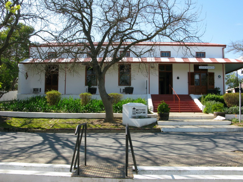
#4. This house was built in the Victorian style shortly before 1800. It is a good example of the style earlier buildings in the street were changed to when their thatch roofs were replaced with corrugated iron and ogee (s shaped) corrugated iron roofs added to the stoep. What you see here looks just like the original building. This building is now the museum with photographs of the history of the town & area. The old church opposite is also part of the museum with interesting things in it. I will discuss it & some of the contents later in this thread.

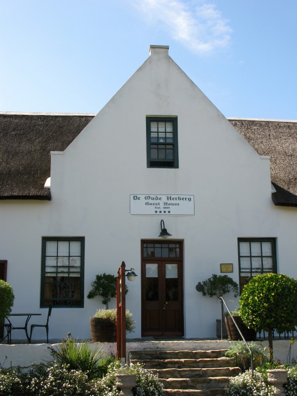
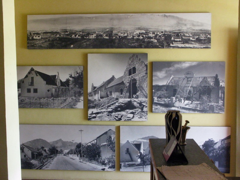
Here is a very simple gable. Gawie Fagan restored the buildings faithfully according to this photo in the museum:

That top photo was taken in 1861. #6 is just about on the picture at the right. Below it you can see photos of the rebuilding of some of the houses; notice that they remove all the plaster so they can see where the original windows and doors were and their true size from the brickwork. There were seven houses with this plainest of gables in Tulbagh. It was an utterly characterless corrugated iron roofed house without even the loft windows like a shed before the earthquake.
#8 Demolished
'----------------------------------------------------------------------------------
The VOC authorities did not want the Cape to develop into anything more than a small station to replenish the food & water supplies of their trading ships. Their requirement for meat resulted in expansion of the settlement; the local cattle & sheep herders (khoisan) were reluctant to trade breeding stock. In 1658 a party was sent out from the fort to try and barter for cattle, one of that party got to see the Tulbagh valley (initially known as Roodezand) but it appeared to be uninhabited to him. Forty years later (1699) the next traveller to see the valley was Governor Willem Adriaan van der Stel. It created a very good impression upon him and he arranged for settlers to be sent there in 1700.
This was the beginning of white settlement in the valley. In 1743 a church was built. A parsonage (pastorie) and house for the sexton were also built but there were no other residents around the church – it served the local farmers who had had to travel to Paarl previously for church. Fifty years later in 1794 the church was too small for the local farming community of about 40 families so the church had to be enlarged. To fund this they got a surveyor in who laid out a row of erven along the track from the pastorie to the church. These were offered for sale & the money raised used to pay for the additions to the church. (This became a common practice for church towns thereafter.) In 1803 there were 12 houses on this road.

In this picture you see the church on the right and the parsonage (pastorie) on the left with Kerkstraat joining the two. The plan is for about 1852; the town had expanded into another street (Achterstraat) by then. The two houses on the right are not aligned to the street. The twelve houses facing Kerkstraat had gardens running right down to the river – in those days you had to provide your own food & that included the predikant who had quite a decent sized piece of land at the pastorie.
So those houses date from about 1800 and were built of local materials. The authorities built a Drostdy (magistrates Court) in 1804; this was the second one outside Cape Town (Stellenbosch was the first). The British took over control at the Cape in 1806 and one of their Governors founded a new settlement at Worcester in 1818 and built a Drostdy there – but it was a sub-Drostdy to the main one in Tulbagh. In 1822 the Drostdy in Tulbagh was damaged in a violent storm & the Governor used that as a pretext to close it & make Worcester the only Drostdy in the area. This had a stultifying effect on the development of Tulbagh so little happened there and the town was preserved much as it had been. In 1969 there was quite a severe earthquake that badly damaged many of the buildings in the area. Because of its history the layout of the town was very much as it had been though the buildings had been altered over the years. Architect & architect historian Gawie Fagan & Hans Fransen were very aware of the preserved nature of the town & they rushed out there the next day to see what had happened. They quickly realised that with the financial support of Anton Rupert and a specially formed Restoration Committee there was a real possibility of rebuilding Kerkstraat to be a faithful representation of what the buildings had looked like before.
I was very fortunate to have gone there last Saturday with the VERNACS (Vernacular Architecture Society of South Africa = Volksboukundige Vereeniging van Zuid Afrika) and both Hans & Gawie were there. I want to show what the buildings look like now 40 years later.
I will show photos of each building and add a little note about them. I am going to go through the buildings by street number, starting from the church end at the south. It will be a bit like a stroll down the street with me saying something about each building. We were there in the morning so the sun was behind the gables I assumed that all that would really show in the pictures was the outline of a dark shaded building against the bright sunlit sky behind. In fact modern digital photography is able to show both the bright sky and a surprising amount of the detail in the shaded part of the building we are looking at. I had expected to have to simply write about the shape of the gables but now I need to do quite a bit more than that. We (Antonia & I) have ’Church Street in the Land of Waveren’ by Gawie & Gwen Fagan so I can tell you what the buildings looked like before they restored them.

#4. This house was built in the Victorian style shortly before 1800. It is a good example of the style earlier buildings in the street were changed to when their thatch roofs were replaced with corrugated iron and ogee (s shaped) corrugated iron roofs added to the stoep. What you see here looks just like the original building. This building is now the museum with photographs of the history of the town & area. The old church opposite is also part of the museum with interesting things in it. I will discuss it & some of the contents later in this thread.

Here is a very simple gable. Gawie Fagan restored the buildings faithfully according to this photo in the museum:

That top photo was taken in 1861. #6 is just about on the picture at the right. Below it you can see photos of the rebuilding of some of the houses; notice that they remove all the plaster so they can see where the original windows and doors were and their true size from the brickwork. There were seven houses with this plainest of gables in Tulbagh. It was an utterly characterless corrugated iron roofed house without even the loft windows like a shed before the earthquake.
#8 Demolished


