Solo to Darkest Africa with Google Earth Virtual Tour

This site may earn a commission from merchant affiliate links, including eBay, Amazon, and others.

JonW

Grey Hound
Staff member
Global Moderator
Joined
Aug 28, 2006
Messages
7,623
Reaction score
1,491
Location
Hilton KZN
Bike
Boss Hoss (all models)
When I go on a new route i like to plot the route first on Google Earth ( I don't have a GPS ). Then I either send the route to my buddy Outthere, who loads the route onto his GPS and I just follow him, or I try memorize the route if it is not too complicated, or I make notes and take them with and refer to them on the ride.

I have never been to Darkest Africa in the Tugela valley, so I plotted a track on Google Earth and made some notes to take with.

DSC02842.jpg


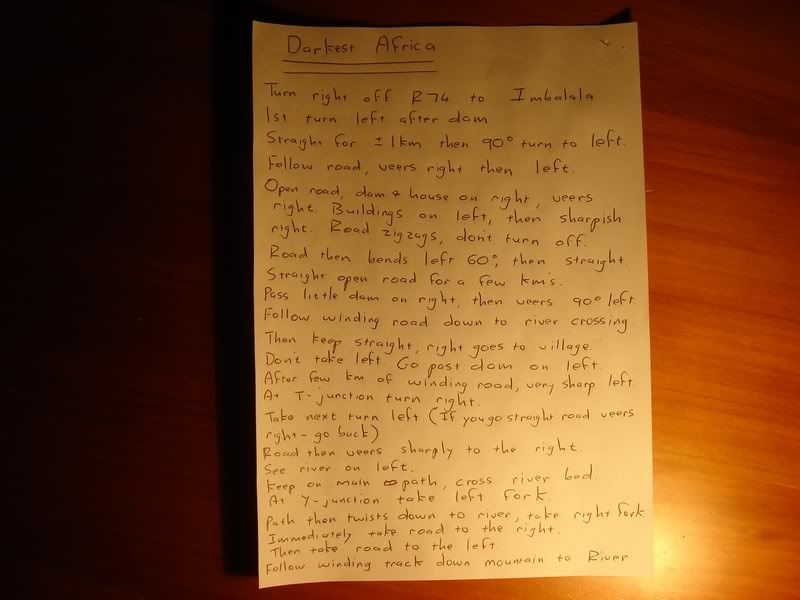
The track is attached at the bottom of this post.

Save it and open it, Google Earth should automatically open.

Highlight the track "Darkest Africa trip" then click on the "Play Tour" button just under the Places list.

This will take you on a Google Earth Virtual Tour of my route.
 

Attachments

  • Darkest Africa Trip.kml
    60.1 KB
I set off fairly early, around 7, headed out through karkloof, then onto one of my favorite tracks down

thebackofCraigieBurn


DSC02846.jpg


DSC02847.jpg


DSC02848.jpg


DSC02850.jpg


DSC02852.jpg


DSC02853.jpg


DSC02854.jpg


From there past the Mooi River falls and then down a nice track onto the R74, then turn off to Imbalala Lodge and hit the dirt trail through the bush.

DSC02855.jpg


The trail starts off as a fairly easy dirt track, but towards the end gets pretty technical. The track goes through some great unspoiled bushveld, lots of wildlife like Impala and reedbuck to be seen.

DSC02856.jpg


DSC02857.jpg


DSC02858.jpg


DSC02861.jpg


DSC02863.jpg


DSC02864.jpg


Sad to say my manuel navigation system let me down and I got hopelessly lost. The track just seemed to peter out and I found myself in the middle of the bush, surrounded by mountains, thorn trees and rocks. i spent a few hours blundering around the bush in 36 degree heat until I eventually found my way back to civilization.

DSC02865.jpg


DSC02866.jpg


I think next time I will just send my track to Outthere to put on his GPS and I will just follow him.

 
Nice one Jon. Pity our paths did not cross.

Thanks for the RR :thumleft:
 
Not good Jon

Riding in darkest Africa all alone you could have been taken out by a lion and no one
would ever have known.

Very brave but glad you home safe and thanks for those pics on google earth of mooi valley

Next time call me .

Hey Badger you should be lucky your paths did not cross between the two of you I don't think
you would have made it home by now.

Reminds me of before gps this was allways part of the adventure [Getting lost]

Thanks for taking the time to take pics and then post them defiantly some good riding to be had there.
 
:thumleft:

Like the paper route map...ols school rules.
 
I believe your        General    sense  of    Direction    deteriorates  with  age  and  GPS  just gets more and more advanced.
 
That looks like a lekker ride. BTW, not all who wander are (completely) lost.
 
Top