How three F800GS's lost a dam...

This site may earn a commission from merchant affiliate links, including eBay, Amazon, and others.

dakardrix

Pack Dog
Joined
Nov 25, 2008
Messages
419
Reaction score
0
Location
Pretoria
Bike
BMW F800GS
Here goes my first ride report..

https://wilddog.net.za/forum/index.php?topic=25779.0

Tuesday, 16 December 2008 dawned, all cloudy and I wondered whether we should set off.  But, if nothing else, a breakfast in Cullinan will do me fine.  So off I charge from Rietvleidam to Cullinan.  Got there way too early, but my buddy Willie (Chuck Norris - not a WD) also pitches early.  We tried to find a working pressure gauge to drop tyre pressures - not one at three garages!  So I just guessed.

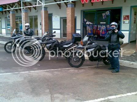
Then it was off to the Wimpy to meet rubiblue  O0 for the first time.  Didn't take a clear picture but here's one I found on the web, as well as the track.  Very little overlay between the planned route and the eventual track.  I gotta figure out how to plan a route and then tell the Garmin not to re-route it as we go along!!!

20081216002.jpg


Attachments

  • rubiblue.jpg
    rubiblue.jpg
    16 KB
  • Chuck.jpg
    Chuck.jpg
    80.9 KB
  • Loskop 2008-12-16.JPG
    Loskop 2008-12-16.JPG
    213.5 KB
  • Loskop 2008-12-16.gpx
    122 KB
Yip, those 'Dark Magnesiums' are the coolest!  Only problem, you can't tell the other okes how awesome the bike is, when you start they just give you the, "Yes, we know!" look!!!

Anyway, we managed to have three different approaches to accessories and packing...

20081216001.jpg


After a quick Wimpy brekkie and Megacoffee, we set off to the first geocache and where the tar stops.  I forgot to take a pic of rubiblue finding his first cache (GC18NDE NOLY - Malansriver Micro https://www.geocaching.com/seek/cache_details.aspx?guid=d6fc1201-3c2f-4185-83c2-1240cb58274f) .  He looked a bit underwhelmed by the small find, but I think the bug started biting... :lol:

At this point I started realising the carefully planned route - based on two very different trips where I just followed and didn't have a GPS - was being changed by my Garmin as we were riding, so I just had to make it up as we go along.  Again.

This caused us to stumble upon a lovely stretch of tweespoor - hope it wasn't private ground, but it gave us big grins as we started negotiating the snotty mud, my nemesis!   On a piece of tar in between, Chuck and I was also shown how to save the front wheel.  It was at this point that I realised I was the slow one.  But at least my route started working out fine...

20081216004.jpg


After the stretch of off-road with lovely rock formations and some slightly technical stuff, we came upon a little valley that looked vaguely familiar to me...

20081216005.jpg


The road was now looking very wet, so I crawled along - I'll tame this mud fear one day, I hope.

20081216008.jpg


20081216011.jpg


In awe of the wonderful world so close to Gauteng, we proceeded on this road, passing groups of horse riders and the lush countryside, stopping to enjoy the Wilge river that flows into Loskop dam.  I even paddled down this river once, a long time ago.

20081216014.jpg


20081216013.jpg


20081216012.jpg


And so the road continued, the beauty starting to bore us stiff (sure!)

Then, we got to this tar road and I'm convinced the Loskop dam wall is to the right.  Well, the sweepy pass was quite a surprise to me - including the wobble on my front TKC that is now at low pressure, remember?  After about 30km of this road, I decided to stop and investigate.  No dam visible on the Garmin!  We lost it?????  I tried 100m of a gravel road, then some more frowning at the stupid GPS (of course, no stupid user!) and we went back to where we came from.  Eventually I figured out we are still miles away from the big Loose Head Dam, but at least that means lots of fun still to do!  Back to the gravel and mud...!

20081216016.jpg


20081216017.jpg


Going over and through the hills and dales and panoramic views, I actually became quite emotional - what did I do to deserve being in such an awesome piece of country and on probably the best bike possible?

This time, we found the dam properly, but couldn't locate the Labourer's hand cache (GCXJKF), a geocache I found before.  After the rains I expected the dam to overflow, but we were not that lucky.

20081216018.jpg


20081216019.jpg


Next, we were now to find two new caches to me - one multi and one micro.   The first waypoint for the multi (Selons-Aloe GC1EW40 https://www.geocaching.com/seek/cache_details.aspx?guid=c167b92d-2d08-4399-96a7-e4d64b570353) was quickly found - it contained a domino piece that you needed to calculate the next point.  Sounds complicated, but really simple.  Then, a quick detour to find the micro Ruby River (GC1GFM4 https://www.geocaching.com/seek/cache_details.aspx?guid=7ce73e51-c7ef-4f9f-a853-2081d4ebecd9 before we searched for the second waypont for Selons-Aloe.

20081216021.jpg


20081216020.jpg


The second point led us into another stunning valley and the road was getting wetter and muddier as we were riding into the rain.  By now rubiblue has turned into the serious geocache hunter and after climbing ridges with heavy boots and gear found it in no time.  Another domino and we could calculate the final co-ordinates, even further down the valley and deeper into the rain.

20081216023.jpg


20081216024.jpg


On the way we had to stop and wait for two trucks transferring some cattle.  Looked a bit suspicious to me, but like good Safricans we didn't get involve and skidded through once they made a gap for us.  It must be noted that at this stage rubiblue started showing his skills and left us for dead, leaving trails that went all over the road.  At least we could follow those.  To his credit he did wait up for us every now and then, but we were definitely in the presence of greatness!   :biggrin:

20081216026.jpg


After finding the final for Selons-Aloe (in the rain!) we retraced our steps and shot through to Groblersdal.  The Wimpy (yes, boring, but you know what you get!) was closed(!) so we had to attack KFC.  Chuck took a tumble, fortunately without the bike, and fell on his broken wrist that is busy recovering from a previous fall.  On the bike that was, but standing still, don't ask, sensitive topic... 

Anyway, that was the only 'spill' for the day.

20081216028.jpg


20081216030.jpg


Straight home from here on the fairly scenic R25, just missing some big rain.  A 500k-odd round trip (about 600 for rubiblue)


Sometimes, the simple rides are the perfect rides.


Nice RR Drix!

YOu are far too kind with your words for my riding abilities, i must say its easier when you dont look...

THanks again for the geocahce introduction, was great fun. We must do this again sometime. The Pace was perfect, yourself and Willie are great dudes, and the area was unbelievable.

Thanks Again.
 
nice ride guys....
dakar, i see u got the shaded contours working on your mapsource... which model gps u using???
 
treemon said:
nice ride guys....
dakar, i see u got the shaded contours working on your mapsource... which model gps u using???

Colorado 300 - I overlap the DEM (shades) and topo maps, just love it when I enter valleys and go through mountains.  On MapSource you can't overlay them, so the effect on the Colorado is way more pronounced.  And of course all my geocaching info is on there as well.
 
rubiblue said:
Nice RR Drix!

YOu are far too kind with your words for my riding abilities, i must say its easier when you dont look...

THanks again for the geocahce introduction, was great fun. We must do this again sometime. The Pace was perfect, yourself and Willie are great dudes, and the area was unbelievable.

Thanks Again.

Nah, you're just modest now!  Was a really lekker ride for me, can't believe how sore my muscles still are, must be my deadgrip on the slippery stuff..  Remember to log your geocache finds, registration is quick and free.  If you want to of course.
 

Latest posts

Top