Lesotho, the hard way.(Complete)

This site may earn a commission from merchant affiliate links, including eBay, Amazon, and others.
g1_ said:
Michiel said:
Awesome! Spread the "word". As photographers we are also artists and what would
art be without an audience to appreciate it?  :thumleft:

What's the point in Fat B spreading the word, when it's impossible to get a copy :p
I'm doing my trip in October and planning on filming, I want to see your DVD before then :)

I am working night and day to get the video finished.
Michiels copy was only a rough cut and still needed lots of work before we can finally make it available to the rest of the guys.

I would not want to make solemn promises but the idea is to get it finished before the CABC.
 
Dustdevil said:
g1_ said:
Michiel said:
Awesome! Spread the "word". As photographers we are also artists and what would
art be without an audience to appreciate it?  :thumleft:

What's the point in Fat B spreading the word, when it's impossible to get a copy :p
I'm doing my trip in October and planning on filming, I want to see your DVD before then :)

I am working night and day to get the video finished.
Michiels copy was only a rough cut and still needed lots of work before we can finally make it available to the rest of the guys.

I would not want to make solemn promises but the idea is to get it finished before the CABC.
Great ! Then I can get my "rough" copy and my finalised copy autographed ?? LOL ! ps .. het jy my e-mail gekry oor daai r100 ?
 
fat b said:
:thumleft: Sorry ek het gedink dalk kom jy CABC toe ? Lucky bugger het jy 'n HP2 ook ?

Sou graag CABC toe wou kom - klink of dit great gaan wees  :thumleft:

Ja, wat kan ek sê? My vrou is baie goed vir my.  :biggrin:
 
Dustdevil said:
I am working night and day to get the video finished.

Yeah right!! As dit nie vir jou forum time was nie het ons al laaaaaaankal daai video gekyk....  :peepwall:  :biggrin:

Sien uit om jou weer volgende week te sien DD!
 
That rocky outcrop just up from the bridge was the spot where the Triumph (not mine) decided to throw itself down resulting in a cloud of oil smoke and subsequent application of Pratley's. Tricky section, particularly after a shower of rain. Thank Ashley Thorne's Roads for Food initiative, it's a spectacular route.
 
Thanks Dusty, looks cool! Somebody recently showed me how to make the video appear like this on the forum.

[flash=460,370]https://www.youtube.com/v/zW3fTIGvXeE&hl=en_US&fs=1[/flash]
 
any reason why you guys never made any fires in Lesotho?

what a cool story,  :thumleft: :thumleft: :thumleft: thanks Michiel!
 
Ashley Thorne - roads for food.  I was with a few Durban guys at the Roof at Ramabanta some time ago (maybe 2005??, when Jade won after Elemer lost it near the finish) when Ashley casually drew in a few ballpoint lines on a map that he'd organised as hiking/4x4/bike trails in the area. They had scouted out tracks that with just some clever route finding and handwork turned into spectacular raods.  I remember 2; the one you roade and one down to the Senqu/Orange from Semonkong then up to the Qacha's Nek Rd.  I had ridden this years ago with a few lads from Matat. In thise days you could ride across the river in winter but now I think its boats only since the Katse Dam. SGB etc have reported on this.

At that time, the route you took was just a line of stones (which we battled to find and Mr Thorne was called some nasty names) down to the river and that stiff pass up towards Semonkong.

All really tough but beautiful routes for a ds bike, demanding except for enduro riders on any other bike. Ramabanta Lodge can advise as well as others on the forum.
 
madmike999 said:
any reason why you guys never made any fires in Lesotho?

what a cool story,  :thumleft: :thumleft: :thumleft: thanks Michiel!

Good question!
One problem was that there wasn't much firewood even if we wanted to.
 
Michiel said:
While this ride report is still rolling I need to ask advice/info...

Does anyone know the current state of "Plothond se pad"?


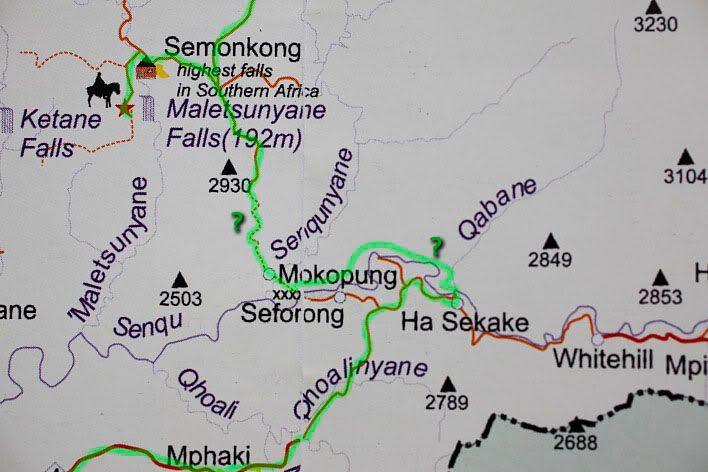
This is the section of road between Semonkong and the Senqu River to the South.

f03.jpg


If I have my way we will be riding this section in December. Go visit the Morena at the bottom of that
"God forsaken mountain" and give her the picture I took. It will be good to know if "Plothond se pad"
is still in original condition and has not been fixed up by the Chinese.

Please let us know if you do.

I will be doing this route in the first week of January 2011. If you haven't already been there by then yet I will report back on it
 
fark i did that route years ago first time up.... then like a dick thort it would be easier down.......on the piece/staggered line below semonkong to mokopung we had to help one another and use locals to push and pull the bike.....camel trophy style se moer.....hope for your sake its in better condition and we where on XRs and DRs those days.....ons het gekak.....i will never forget how i prayed to get out of there.... i was so farked from pulling the bike up the mountain
we where able to ride across the senquyane(little orange) but had to use alluminiam boats to cross the senque(orange river)

dit gaan n leka adventure wees .....just be prepared
 
Thanks for sharing your info Husky and Mother.  :thumleft: Helps to make better planning for the next trip.  :deal:

As far as I can tell the Chinese has since built a bridge over the Senqu River and the road to Semonkong has
been refurbished. One can now travel from Ongeluks Nek or Quatchas Nek to Semonkong with no difficulty.
Or that is what my information sugest.

Please let us know what you find there LuckyStriker. Will be interesting to see what the Chinese has done.

I'm still in the process of luring Dustdevil and the likes into another trippie end of the year. Will go specifically
to travel this section South of Semonkong since we missed out on it because of SACK's injury. Besides the usual
road, as indicated on the map I showed, there are some tracks leading off it on to a fainter track running parallel
but only Westwards, about 2-3km, and ends up directly in Semonkong. This track used to be indicated on Google
Earth's Tracks For Africa and was labelled "bikers and baboons only".

Been in e-mail contact with Peter from the Roof of Africa and although he haven't been on this "bikers and baboons only"
track in ten years he recons it can be done but not without a huff and a puff.

 
Is this "Plothond se Pad" you okes are referring to?

semonkong.jpg


I'm looking at a route to / from the bash, and this fits in nicely with it - does ANYONE know what this is like?


EDIT: Ha, seems it is Plothond se pad... T4A says Off-road, but check this Ride report
 
Michiel: do you mind having a look over a route through Lesotho I'm planning for next month. I haven't finalized it yet, but I'll stick it up in the planning form when I have.
 
"Plothong se pad" turned out not to be as easy as originally thought. We did this route in the reverse meaning that we were going up where Plothond and crew came down.
although a small section of the road has been fixed it is already washed away badly in places.
This is for sure not the pillion and pannier box friendly road is was made out to be recently. Your pillion will divorce you before reaching Semongkong and your panniers will forever have their shape modified to resemble a soccer ball.
 

Attachments

  • IMG_2248.jpg
    IMG_2248.jpg
    85.4 KB
Top