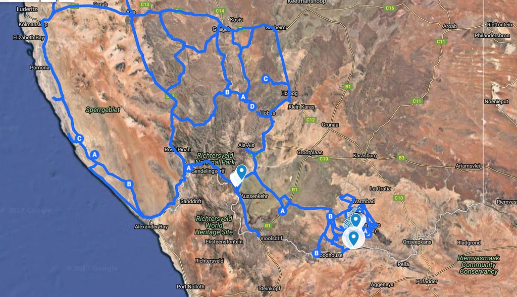
I'm trying to slap together last minutes route through southern Namibia. Basically in the area delineated by Orange river at the south, Luderitz at the north west and Rietfontein on the north-east. I'm looking for offroad tracks ideally similar to Namaqua 4x4 - we are going to be on 690 and TE610 and not particularly interested in spending much time on dirt highways, and sightseeing (though I may need to include Fish River for Straatkat to tick off the list).
Basically we will enter in Sendelingdrift and would like to enjoy as much as possible riverbeds and canyon riding. I haven't seen much offroad riding reported in that area here - may just missed it. So I started tracking routes I can see Googlemaps and so far have mapped the western part of that area like so:

Here is the map in googlemaps, where you can zoom in and out: https://www.google.com/maps/d/embed?mid=1v87BeXpdYhDmI47xJIUGpMjvOh4
I have few questions please:
- Is the westernmost route passing Alexander Bay on the other side of the river and turning north along the coast to Luderitz open to public (I suspect it is diamond concessions off the limit, but would like to be sure)? (not the one through Ros Pinah - the one further west along the coast)
- There seem to be lots of tracks around Sandfontein Lodge and Nature Reserve. Is the area accessible to public and bikes? Can one ride bike through the Hom river that passes through it (Googlemaps do indicate routes there - you can see it staked out in the map)?
- Is the area generally public land or maize of private properties so unmanageable on the bike?
- Where is petrol available in that area?
- Is there a great route/track I am missing in my map? As I said, we are looking for Namaqua 4x4 type of riding (or Amageza type of riding) not main routes.
I will map the remaining part to Rietfontein tomorrow and add it here with more questions.
Thanks in advance
Basically we will enter in Sendelingdrift and would like to enjoy as much as possible riverbeds and canyon riding. I haven't seen much offroad riding reported in that area here - may just missed it. So I started tracking routes I can see Googlemaps and so far have mapped the western part of that area like so:

Here is the map in googlemaps, where you can zoom in and out: https://www.google.com/maps/d/embed?mid=1v87BeXpdYhDmI47xJIUGpMjvOh4
I have few questions please:
- Is the westernmost route passing Alexander Bay on the other side of the river and turning north along the coast to Luderitz open to public (I suspect it is diamond concessions off the limit, but would like to be sure)? (not the one through Ros Pinah - the one further west along the coast)
- There seem to be lots of tracks around Sandfontein Lodge and Nature Reserve. Is the area accessible to public and bikes? Can one ride bike through the Hom river that passes through it (Googlemaps do indicate routes there - you can see it staked out in the map)?
- Is the area generally public land or maize of private properties so unmanageable on the bike?
- Where is petrol available in that area?
- Is there a great route/track I am missing in my map? As I said, we are looking for Namaqua 4x4 type of riding (or Amageza type of riding) not main routes.
I will map the remaining part to Rietfontein tomorrow and add it here with more questions.
Thanks in advance


