Swimming in the Baviaans

This site may earn a commission from merchant affiliate links, including eBay, Amazon, and others.

Zanie

Race Dog
WD Supporter
Joined
Jul 19, 2014
Messages
721
Reaction score
165
Location
Table View, Cape Town
Bike
Honda CRF-250 Rally
Prequel

The initial plan for the December holiday season was a different type of RR: Rest and Recover; not Ride Report. Yet all it took was an invitation from previous neighbours (now living in Plett) to visit. That got the brain ticking. Why only Plett? Is not Baviaans somewhere in that general direction? Leave applications were sent, accommodation bookings were hastily made and Lance and I headed off 2 weeks later.

It would be our longest bike trip yet, at 8 days. It was a test of some sort, considering we will be heading off to Namibia in May this year and I have only ever done 4-day trips max. The scenery and accommodation would be varied: from camping, tackling a pass that we were told was sworn off by some bikers and the locals, and areas so desolate we didn’t see another vehicle in hours; to high-style freebies and the bustle of Plett on New Year’s Day (not for the faint-hearted).

One of the middle-of-nowhere spots
37049345735_607ee5ab33_b.jpg


Shortly before our trip, as a birthday present in the form of a “free workshop” and skills-building exercise, Lance made me remove my own wheels and tyres, rather than let Trac-Mac do it for me, when I went to get new knobblies. I was pretty chuffed afterwards; knowing I need fear the idea of a puncture no more. Not only did I now know the theory, but the practical as well.

Putting the wheel back on - with new knobbly
36652617270_13ed85ce41_b.jpg


I would get an opportunity to use my new-found skills during our trip …

The routes are available in 3 formats. For the techno-ninja, all the gpx files can be found in my Dropbox (for a limited time only – who knows when I’ll need to create space again). For the middle-of-the-road person, there are Google Maps links, where you can zoom in/out (caveat – Google doesn’t believe in the existence of some of the roads we travelled). For the technophobe there are pretty pictures.

I have added statistics for those interested: route distance, moving time and total time (includes stops along the way). Note: I am a (very) slow rider.
 
Day 1: Cape Town to Herbertsdale area

Distance: 419 km
Moving time: 06:02:04
Total time: 08:16:33
Click here for Google Map

37049361355_3531208558_z.jpg


Note: This is not a video (you cannot press the play button) – it is a screen grab from my Garmin page.

The first day, in essence, was an exercise in trying to get as much distance between us and Cape Town as possible; hence it was the longest day in distance. We were not sure what happened to the holiday crowds. Route 62 was a dead zone (bliss!). The apparent reason: everyone was in Barrydale! We were lucky to find a spot at Diesel and Crème, where we had their legendary it-is-a-meal-on-its-own milkshakes.

Lance and his Turkish Delight milkshake – you need that thick straw!
36908413151_f2db62a3f1_b.jpg


On the road again, milkshake was replaced by water, as we tried to stay hydrated.
37049363985_f6cee77acb_b.jpg


We hit the more scenic roads.
36214628054_210cef3825_b.jpg


The upper reaches of Gouritz River:
36908410981_9283b0f7d7_b.jpg


We camped at Dwarsrivier Country Getaway; a biker-friendly spot, run by Martin and Jenny, complete with pub, camping and roofed accommodation. We were their first campers on our trip in September last year and more than happy to return.

Chatting with Martin:
36908410511_412994a2b9_b.jpg


Supper consisted of braai-packs, pre-ordered with Martin and Jenny. Lance had to do some washing beforehand though. A can of (non-fizzy) juice had chafed through in his top box. One small hole resulted in a sticky juice layer at the bottom of his top box. Most of his clothes were safely out of harm’s way, either in the upper reaches of the top box or in another bag entirely. Lucky for him.

Me setting up camp while Lance braais us some food (or takes some photos):
37049362045_b6aa8a5f32_b.jpg


It would be the only night when we would wear long pants/ socks/ closed shoes. The temperature explored the upper reaches of the thermometer for the remainder of the trip.
 
Day 2: Herbertsdale area to Baviaanskloof

Distance: 308 km
Moving time: 06:02:30
Total time: 07:53:49
Click here for Google Map

36241839983_5ecefa8070_b.jpg


I was awake by 6am. It took the heat of the sun to chase Lance out of the tent an hour later. The relentless heat would be one of the enduring memories of this trip. Any temperature below 30°C would be classified as “cool.” The average status quo was 35°C, but it climbed even higher...

We had a breakfast of nuts, before heading off. We always bring a large packet of nuts along on trips. It’s a great food fall-back, packs quite small and is very energy-dense.

Our day started with some passes.

Hagelkraal Pass:
37049384725_d1c70cd66d_b.jpg


Robinson Pass:
37049384315_361afc60c6_b.jpg


Outeniqua Pass:
37049384005_fbba74abc2_b.jpg


Just before we climbed on to Montagu Pass, my fuel light switched on (I do not have a fuel gauge). My reserve tank is quite large (I have gone 70km on it with more to spare), but we decided to go with some sage advice to be found on this forum: "In Africa, when you can, fill up with petrol. You only have too much fuel when you're on fire."

We stopped in George for some fuel. Lunch consisted of ice-creams (so nice and cold!) and muffins.
37049383435_1cf92366da_b.jpg


Next up: Montagu Pass
37049383095_d35cf84109_b.jpg


I pitied the cars on this route. There were some pretty mean speed-bumps. Fun for us. Not so for the cars.

Lance is always looking for “interesting routes.” Sometimes they work; more often they don’t, but they are definitely interesting!

This one ended up at a gate that was creatively and inextricably tied together with various pieces of string:
37049382295_aeef5cf20e_b.jpg


We stopped many times to catch a bit of shade. As a light is to a moth, so a lonely tree was to us.
36241845693_566674be0b_b.jpg


Next was the Kamanassie road
36241844993_26a90cdf98_b.jpg


I spotted goats up ahead and braked hard. I don’t fancy going past them at any speed other than a crawl.

Potential speed bumps
37049380695_9ba79d6c2e_b.jpg


There was a rather puzzling sign, with no further indication on the route as to its purpose.
36241844173_42eda428d0_b.jpg


Somewhere along the Kamanassie Road we spotted some bikers while we were, yet again, resting in the shade of a tree. We gave a friendly wave and one poor soul almost rode off the road when trying to return the favour. No worries. We’ve all been there. Drop your guard for a moment (my usual nemesis is a beautiful view) and you may become part of the road-side scenery.

It was also at about this point that Lance’s Garmin died. His cycle computer does not take kindly to being used as a GPS and route-finder. When it dies, it dies properly. The only way to start it again is a reset. Poof! Gone are your routes. Sort of. They were somewhere on the SD card, but the Garmin only reads internal memory. That meant we had to rely on Lance’s internal memory.

Shortly after the Baviaanskloof turn-off, I heard Lance tell me to “watch out” (this was our first long trip with headsets). It looked like he had stopped close to a large pile of dung. It was actually something that had expired violently. I only realised what it was when I was almost on top of it.

Taking the gap
37049379535_dd305b0ea1_b.jpg


I have been through Baviaans many times before, but always in a car or as a pillion. It is something special to ride it on your own bike.

The Nuwekloof Pass at the Western entry of Baviaans:
36241843003_f7af4167e6_b.jpg


We stayed at Uitspan, in order to leave an entire day to ride through Baviaanskloof at a leisurely pace.
36241842453_d5a75dd40b_b.jpg


We had been lucky when enquiring about accommodation a week beforehand: there was no camping left, but there had been a cancellation for one of the houses. Christine booked it for us without requiring an up-front payment, as she could remember us from two previous visits and trusted us. I was very glad to see her dog, Blackie, up and about again. Last time I saw him, he was in incredible pain after being hit by a local with his bakkie.

Lance still hadn't learnt his lesson. This time, thankfully, it was a water bottle that sprung a leak in his top-box. He refrained from putting any liquids in his top-box for the remainder of the trip.
36241841953_0ff5c99d5a_b.jpg


Uitspan has a foefie slide, which Lance decided to investigate. It had been too cold during our previous stays to even consider swimming.

Lance during touch-down
37049377185_6c89f9eeef_b.jpg


My superpowers: walking on water.
36241840503_0cc3daf3ee_b.jpg


Supper consisted of a braai pack and roosterkoek, ordered from Uitspan.
 
Day 3: Baviaanskloof

Distance: 122 km
Moving time: 04:30:44
Total time: 06:56:30
Click here for Google Map

36241871583_fbea550218_z.jpg


Today would be the shortest with regards to distance (but not time). We were wondering where we would source supper, as the indication had been that no food was available at Bruintjieskraal (we found out later that you could order braai packs, despite information to the contrary when I phoned them a week ago). Christine, from Uitspan, was kind enough to phone a place along our route, Baviaans Lodge, to enquire about food. Baviaans Lodge had a big group for supper, but said they could organise some chicken pie for us. We only needed to phone ahead once we were close to Bergplaas; one of the only areas with signal in Baviaanskloof, roughly 30 min away from Baviaans Lodge.

We also asked Christine about Antoniesberg Pass, which we were planning to do the next day. We had heard that the approach road from the Patensie side was in a bad condition. Christine told us that some bikers had ridden over it from the Steytlerville side and said “never again.” Her husband, who runs a 4x4 trail, had taken his bakkie there 3 years ago and his response was similar. Apparently there had been 3 bad floods without any road maintenance. Hmm.

For today, I had been worried about the water crossings, but Baviaanskloof was quite dry - relatively speaking. That didn’t mean there weren’t water crossings. We tried for big splashes in the shallow crossings. It was a welcome relief in the heat.

36652691070_c9194b20b7_b.jpg


36214674994_2814ca222a_b.jpg


This one looked deep, so we decided someone should check it out.
36214674814_e1ebbb8832_b.jpg


That “someone” ended up being me. It was a good thing we did end up checking the crossing. There was a deep hole on the left.

36214674514_2ae8212b3b_b.jpg


My boots are waterproof. In essence, it means that if any water gets in, it doesn’t get out again easily. My boots started gaining personality from this day; getting stronger as the days progressed.

36214674074_11d0f9090b_b.jpg


Taking the shallower line
36214673724_349513ef4e_b.jpg


We reached a muddy water crossing that was a nasty surprise. I could not find it in my memory filing bank (not too surprising, but Lance didn’t remember it either). Was this Smitskraal? Nope. Just another long crossing.

You do not want to fall over in this
36214673314_565d8e6981_b.jpg


There were quite a few cars in Baviaans, but not as many bikers. We spotted a group on BMWs, with a lady on a 700 – good to see!

One of the BMWs
36214672744_fb29356561_b.jpg


And there was a Mom, Dad and Son group on DRZ400s and a CRF250 (according to Lance’s observation). It’s nice when a family can ride together. We stopped for a chat on Grasnek Pass.

Gransnek Pass
36214672264_9b1ba0ba4f_b.jpg


“Dad” from the family group at the lookout point on Grasnek Pass
36214671984_6d5264d641_b.jpg


They mentioned that it is a lot more fun doing this type of road on smaller bikes. I do not doubt it, but I shy away from the financial burden of maintaining an armada of bikes. I had to choose a long-distance traveller, regular commuter and off-road capabilities compromise (don’t we all?).

Our group discussion then turned to the most important point of the day: where to cool down. Lance mentioned a spot a bit off the beaten track that he saw on Google Earth. The family group usually swam at one of the river crossings.

The crossing was very busy though…
36214671504_30b7bba3f3_b.jpg


All of us decided to look for the off-the-beaten-track swimming spot. The family group were ahead, but turned back with their report of “no water found.”

36214670884_b81f92760a_b.jpg


We decided to continue nonetheless
36214670214_5dbe92c236_b.jpg


The road ended at a very dry and desolate picnic spot, with no sign of any water. The path did continue though. The only problem: stairs. Lance convinced me that he could see dual tracks, which meant that “cars must pass this way.” Yeah right. Somehow I always get talked into these things, so down the stairs we went.

36241877853_c3948f8f47_b.jpg


We followed a walking trail
36241877503_119fc70b85_b.jpg


And came upon this! The Kouga River.
36241877143_e4e83184aa_b.jpg


We parked off in the shade of some camelthorns; having to mind the flipping long thorns scattered strategically on the ground.

36241876833_1bdcdc5ac9_b.jpg


There was not a soul in sight. Hmm. We didn't feel like lugging around wet stuff. Solution of the day: skinny dip and drip-dry!

No further photographic evidence!
36241876113_691266587f_b.jpg


When I got back to my bike, I noticed the clock had reset. Perhaps it had a heart attack in today’s heat. What worried me more is that my bike’s idling was very rough and it would cut out easily when pulling off.

Despite this, I still managed the stairs without stalling
36241875673_506328604b_b.jpg


We finally reached the legendary Smitskraal. It was very shallow, thanks to the drought, but the large cobbles made it tricky. My bike also wouldn't idle easily in low gears unless it was kept at high revs (this problem would persist to a greater or lesser degree throughout the trip).

36241875133_68f8a2e101_b.jpg


Shortly after entering, I hit a cobble, rolled off the throttle and the bike stalled. I managed to semi-duck-walk until the surface became more manageable (somewhere from the mid-way mark).

36241874693_63df42bb78_b.jpg


What stunning scenery!
36214665444_95c0b773f5_b.jpg


We finally arrived at the concreted tweespoor. The concrete had made the road easier to drive/ride for probably a year, maybe two, after its implementation. Thereafter, when it gradually disintegrated, it just made it more “interesting.” I actually found it quite fun! As long as I could ride it at my speed (read: first gear!) then it was great sports looking for the best track. Was it to the left or right? I pitied cars, as they must look for two tracks. I ride very slowly, but yet not one car passed us. They have to drive even slower!

37049409875_f5820fbda6_b.jpg


The road was incredibly narrow for most of its length. Some people (mostly with GP plates) are crazy enough to drive it whilst towing trailers. We passed one vehicle with a trailer and soon saw two cars coming from the front. We wondered what would happen when they met, as there were no easy turn-around or passing points. Shortly after, we stopped for about 15 min for a visor-cleaning break. We didn't see the trailer vehicle in that time. There was obviously a hold-up as the vehicles tried to sort themselves out. Someone would have to reverse a long way…

Living life on the edge
36652683110_ec52a5cb47_b.jpg


36241873133_1403b9be38_b.jpg


Our supper would be early, as we arrived at Baviaans Lodge (our food stop-over spot) just after 3pm. We had banked on some small chicken pies (like the type you get in the shop). Next thing, this huge home-made chicken pie was placed on the table, along with similarly sized bowls of salad, home-made chips (not those damn pre-frozen types) and beetroot. There was a keg with ice, beer and coke, along with a big jug of iced water (the water, in particular, was finished in record time). It was an absolute feast!

36652691530_a8eeb8a579_b.jpg


Happiness is…
37049408575_65f4caf0e8_b.jpg


We headed off to Bruintjieskraal, our campsite for the night, full and happy. Again, at Bruintjieskraal, we asked about information on Antoniesberg Pass. Not many people seem to ride that way and even the locals give it a wide berth. The only additional information we got was that it would be easier from the Patensie side, as you would be heading downhill on the really bad section.

The usual Bruintjieskraal campsite had been fully booked, but we were offered the spot by the lapa, next to the water reservoir. This was truly “glamping,” i.e. glamorous camping. We had the entire place to ourselves; aside from the resident swallows, who had a nest under the lapa eaves. Unfortunately the gas for the shower had run out, but a cold shower was not such a bad idea, given the heat of the day.

36241871853_4e5b90d4e7_b.jpg


We put my bike on its centre stand and tested its idling – not sounding too healthy. So it was not “all in my head.” The diagnosis from my mechanic after the trip: the air filter and throttle body had been full of muck.

A couple who was staying in the chalet accommodation came to have a look at the reservoir. We advised against their plan of a swim. We had been watching, with interest, the various signs of wildlife that could be seen in its murky depths. There was definitely some sort of fish in there, along with frogs and many other little critters. We heard signs of other, less welcome wildlife very close-by: the call of a baboon (we had seen many during the course of the day).

36652681890_380d66c0f4_b.jpg


Our sleep was disturbed by two things: the oppressive heat and Lance’s nightmares about baboons! When he woke up, I think he had difficulty distinguishing between dream and reality. He was convinced some baboons were in our campsite. I was woken up by a worried Lance. All the creaks and groans from a lapa settling in the (marginally) cooler night-time temperature was interpreted as malevolent wildlife. He was worried that the baboons would steel his GoPro; drawn to it by the flashing LED light (while it was charging). I told him that baboons would be more interested in food (the little we had was packed securely in zip-lock baggies in the top-box) and he should go to sleep.
 
Day 4: Baviaanskloof to Willowmore via Antoniesberg Pass

Distance: 243 km
Moving time: 05:51:40
Total time: 08:03:20
Click here for Google Map

36908493051_ffb5f3e0be_z.jpg


Since we had a kettle at our disposal, we had some cappuccino and rusks for breakfast. We always travel with rusks and instant cappuccino on the off chance that we happen across some boiling water…

We said goodbye to Baviaans, heading to Patensie for some fuel…
36214709824_a38da72df9_b.jpg


…and then doubled back roughly 5km to take the Elandsrivier road in the Willowmore direction.
36214709394_afdfdf8eb4_b.jpg


It had been decided: we would try Antoniesberg Pass

Early on, the scenery demanded your full attention.
36214709104_e89835fbe7_b.jpg


This could be a problem, as the road progressively got worse. I hit a pot-hole hard and almost immediately started hearing a strange sound coming from the back of my bike. I stopped, thinking I had picked up a rear puncture. My poor bike endured some tyre-kicking before I was assured that my tyres were fine. I did a slower lap around my bike, this time looking for fluids. Nope. The next lap was made at snail’s pace. I spotted a blackish mark at the base of my number plate. Then I knew where to look for the trouble.

36214708134_f40e0487e8.jpg


My bike has a history of shedding bits. The back-end once rattled loose completely on a previous day-ride. It was hanging by a thread (actually a wire in that case). I lost my number-plate during that ride.

36878979742_b4f8da3839_b.jpg


This time round it wasn't just a loose screw that was the cause. One of the plastic mounting pieces had sheared off. The number-plate had been dragging on the back tyre; hence the black mark and strange noise.

Lance eventually realised I was not in his rear-view mirrors and headed back. The cable-ties were at the bottom of his bag, so we went with the option that was easier to reach: duct tape. Never leave home without it!

Nothing that a little duct tape can’t fix!
36214708684_bdd188b473_z.jpg


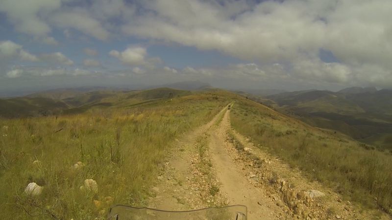
See the tweespoor on the left? That was our route.
36214707634_631c45ecb8_b.jpg


The road is nicely sign-posted (Grootrivierpoort), but do not let this fool you into thinking that this is a “gravel highway.”

36214707174_13d285017e_b.jpg


There was no gradual road deterioration. Within the space of 10-20m, the road went from passable to really, really rough. The warning signs were loud and clear. Given this, at least from the Patensie side, you are afforded the luxury to make the decision on whether to turn around quite early into your trip. I was game for the challenge, so we headed onwards. My fear is sand; not rocks. As long as I can ride slowly on the technical bits (read: first gear), I am ok.

36214706814_8f8e135d5a_b.jpg


The view was indescribably beautiful. This is what I imagine Lesotho must look like. In contrast to the main Baviaans route (called T1), the T2 (Grootrivierpoort) route travels on the mountain ridges rather than in the kloofs.

36214706224_7fe906aca8_b.jpg


This road will be far worse in a car. On a bike, you have more options, including completely off the road!
36652729990_4f471c42c8_b.jpg


More stunning vistas
36878975482_1b346f11af_b.jpg


36878975142_589120a072_b.jpg


36878974692_720f841a34_b.jpg


Perhaps not the best line…
36878974212_f142947ae6_b.jpg


Don’t fall into the donga
36878973672_b5be4e7c47_b.jpg


Pick a line!
36652727790_44e062c7d1_b.jpg


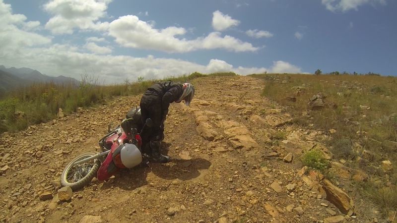
The following piece of road was the only stretch where the fear-factor kicked in. It does not look bad on the photo below, but photos tend to bugger around with depth perception. The gradient is incredibly steep and the footing is loose and stepped. The road also curves to the right. Or at least one of the options goes in that direction - from about this point onwards, the road splits a number of times as people tried to find a better route. We wanted to head right, because there was one lonely tree that could offer a patch of welcome shade in the blistering heat of the day – see it?

36652727280_58f71896ca_b.jpg


At this point I lost my mojo. I picked a bad line, went over a rock step, freaked out, hit the brakes and hit the deck. My left foot was wedged toe-down into the ground, with the weight of my bike resting on my heel. If not for the steel shank in my boot’s sole, my foot would have been folded in half or my Achilles torn (this happened to a friend of mine). As it was, I was stuck good and proper and the pain was increasing as my foot was being squished. I could not pull my foot out from beneath the bike.

Meanwhile, Lance, who was ahead, heard my bike go down through his headset (you get a tell-tale revving noise when the throttle is not yet disengaged but your wheels have disengaged from the earth). He turned to look at what had happened and promptly had a side-stand incident. Great. I could not expect speedy help from that quarter. In the end, I managed to forcefully drag my foot out of the boot (the boot still stayed put). My foot was sore for a bit afterwards, but it could have been much worse.

Lance’s perspective as he walked back up the steep curve to get to me.
36878972042_5108e4a2a7_b.jpg


You get a better idea of the road’s condition and gradient from this angle.
36878971042_47a9a20c12_b.jpg


Note to self and anybody out there who wants to follow this route: I would not want to ride this route in the opposite direction (from Steytlerville/Willowmore to Patensie) or in the wet. Some crazy people have done it though.

Thinking about life and my boot, which is still stuck somewhere beneath my bike.
36878970202_8b38e6cdfc_b.jpg


I went over the rock step on the right
36878969272_efdeb4ce5f_b.jpg


Me and my trusty boot. I’d broken a foot only 18 months previously. I don’t mean to do it again.
36878968312_aef39fbe6a_b.jpg


No fluids or damage (or at least no new scratches that I can distinguish from the plethora of existing scratches). A fall at 5km/h doesn’t have too much damage potential other than the squash factor.
36878967612_b57ab7eab2_b.jpg


Just as I climbed back on my steed, we saw the first and only vehicle we would see on the Antoniesberg stretch of road. He stopped so as to allow me to continue on my merry way; thinking I would go straight, but I actually wanted to go right towards the shady tree. Now I had to turn sharply behind him on steep, loose road without losing it again. Sigh. At least I managed. Lance queried the driver as to the road conditions up ahead. The driver said it was very bad. Could it be worse than the section we had just completed?

36652722870_65da11b92f_b.jpg


Still one more obstacle stood between us and the shady tree (do you see the tree?): we had to lift Lance’s heavily-laden bike.

36652722400_8e660449cf_b.jpg


When Lance’s bike was back in the upright position, I struggled to right my bike, as I had stupidly parked it on a left-leaning slope. Scrap that thought. I am actually just dancing a tango with my machine.

36878965192_38e27da404_b.jpg


We finally reached The Tree.
36878964292_9fe9567015_b.jpg


Its shade was incredibly welcome.
36878980882_b6771c0034_b.jpg


For those who are ultra-observant: yes, I have been wearing the same top for 3 days now. It’s called packing light.

36878980342_7c1ba99e3a_b.jpg


When we continued, we found out that the road actually got better (at least from a biker’s perspective).

More avoidable dongas.
36878963802_94249701cc_b.jpg


36878963022_7093f1d195_b.jpg


Waving to a little kid at the farm gate. I don’t think they see a lot of traffic on this piece of road.
36214695044_8b23ab53dc_b.jpg


We finally reached Grootrivierpoort. The water level was low, thanks to the drought.
36214693574_a043378137_b.jpg


We found a tree with shade. Unfortunately, so did the whole area’s ant population. They were big and angry blighters. Hence, our boots had to sit out in the sun to avoid becoming the next ant colony hotel.

36214694384_06b8f8cec9_b.jpg


If you lay flat on your back, there was just enough water to cover you. Yet again, we had decided to skinny-dip, considering the desolate nature of the road.

36652717520_fd1225098c_b.jpg


At one point, we thought we heard someone approaching. It ended being a couple of someones – woolly someones.

36652717030_1eaa3bc241_b.jpg


The road got much better after the poort.

The route is nicely sign-posted from the other side as well.
36652716320_df22a33c7f_b.jpg


We spotted a wider river as we were heading upwards. That would have been preferable for our swim.

36214690854_e8090b0f0a_b.jpg


The pass climbed even further. The drop can give you heart palpitations if heights are not your thing. Notice how I’m keeping far left.

36214689864_451e74dce9_b.jpg


After Antoniesberg, we continued to follow the Baviaans T2 / Grootrivierpoort route. I think I would have enjoyed it more if not for the blistering heat. Any shade was an invitation to stop.

36241896123_97ef417887_b.jpg


We cut out a bit of the T2, heading to the R329, as Lance wanted to show me the concrete road towards Willowmore. This piece of gravel, off the main T2, ending up being the most interesting. We saw duikers, vervet monkeys and even a hare.

Unfortunately the only creature of interest we caught on camera were some rams…
36241895273_6524de9c35_b.jpg


…and a whole family of collie dogs.
36241894743_6eefbf95f5_b.jpg


The one puppy showed a bit more dedication than his peers. He eventually did turn around close to the inevitable farm gate.
36214687884_3e7d055c16_b.jpg


East of Willowmore, we hopped onto the 36km one-of-its-kind stretch of cement road. It was built in the 1950s. Back then, cement was cheaper than tar, which had to be imported. One funny anecdote offered up by the Internet concerns a German tourist in a rented vehicle. He threw up his hands in the air and stopped right in the middle of the road when a car approached from the opposite side - he simply did not know what to do!

36214687384_0a912273a4_b.jpg


I suppose this did not occur to him:
36214687654_0225c60ae5_b.jpg


We would spend the night at Jumper’s Place, a biker-friendly backpackers.
36214687134_6498f59172_b.jpg


Lance’s bike was also tired after the day’s exertions:
36908493581_b49990c0f9_b.jpg


Rony showing us around in our digs.
36908493231_c8ec06fc65_b.jpg


We had our second cold shower of the trip, as the geyser had not yet had time to heat up, but we wanted to get clean NOW. By this point in time, my boots had so much personality that they were left to sleep outside. I would highly recommend Jumper’s Place’s steaks. They were huge and yummy.

It was still very hot, even at night, so we slept in our sleeping bag liners, rather than under the supplied duvets. At midnight, I was woken up by ravenous hordes of mozzies. There was no escape. They chewed me right through the liner. Lance’s brilliant plan was to pitch our tent outside, making sure no mozzies got in. We left off the flysheet, so that we could have the full benefit of any breeze that happened to wander along, but the under-layer’s mesh kept the mozzies at bay.
 
Weereens so baie fotos. Julle weet hoe om 'n trip te verewig. Baie nice :thumleft: :thumleft:
 
Day 5: Willowmore to Plettenberg Bay

Distance: 321 km
Moving time: 05:35:01
Total time: 07:20:25
Click here for Google Map

36241941913_418dd51f32_z.jpg


We had breakfast at Jumper’s Place. Rony allowed Lance the use of his laptop, in order for Lance to transfer his routes from the SD card back onto his Garmin’s internal memory, so that the unit can read the routes (all the routes had been deleted from the internal memory on the second day of our trip).

We bumped into a fellow biker at the Willowmore petrol station. He had planned to tackle Antoniesberg on that day. We advised him against this exploit for a number of reasons: he would be attempting the route from the more difficult side, he admitted he had very little off-road experience, and he was alone (no-one to help you pick up your bike).

We had decided to take the long way round to get to Bloukrans Pass, therefore we would spend most of the day on tar, in an effort to bring the travel time down to a reasonable amount.

Uniondale Poort:
37049491885_6c93f5c041_b.jpg


Roughly 7km after Uniondale, we turned left onto the Bo-Kouga road. This would be our only stretch of (planned) gravel for the day.

37049491595_814dd3c157_b.jpg


36241960713_9464320ffd_b.jpg


36241960183_a01eb93ac5_b.jpg


I hoped the biker we met this morning did not attempt Antoniesberg Pass, because there was one factor, becoming more apparent as the day wore on, that would further add to any difficulties: the mercury soared into the stratosphere.

I'm sure the birds of prey were waiting for us to keel over from heat exhaustion:
36241959713_bb4969325f_b.jpg


Even the cows were reluctant to move:
36241959103_13cb3b4731_b.jpg


The Bo-Kouga Road, though beautiful, had a hidden sting: some semi-loose patches. If your sand tolerance is low, as in my case, it will keep you on your toes. All others will probably wonder “Sand? What sand?” The high temperature also made slower gravel riding extremely trying.

36241958343_37ce01502c_b.jpg


Any shade would do. A large tree in the distance meant a quick “conference call” between Lance and me on whether we would stop or not. Mostly we did.

36241957013_ae51cd43c8_b.jpg


My biker kit has mesh in the jacket and pants. It lets a lot of air through. Any temperature up until 38 degrees Celsius (roughly human body temperature) was bearable when riding higher speeds on tar. Then suddenly, as we entered one valley, it felt as if I had entered a furnace. The air burned. Lance informed me that the temperature had just jumped to 40. My Garmin cycle computer registered temperatures far higher (up to 50), but it was in a black handle-bar bag, so it had plenty of opportunity to gain heat. Oh wait… I was garbed all in black as well.

There are two blurry numbers somewhere on that screen: a 4 and a zero!
37049489185_ca960bb6bf_b.jpg


Just before Kareedouw, we doubled back, heading to the N2. We stopped at Oudebosch Farmstall for some much-needed drinks and ice-cream.

We hugged any patch of shade, no matter how small!
36652776120_6d85a8000a_b.jpg


Our route took us onwards to Bloukrans Pass. I have never travelled this pass by bike and wanted to tick it off my bucket list. The pass is technically closed and has been for some years, thanks to a refusal to fix it from the powers that be. The alternative toll route is much more profitable.

36241953263_4189894782_b.jpg


The approach road has a desolate feel.
36652774910_8e8511bac9_b.jpg


You need not fear the “tamelife” (i.e. cows) as much as you should fear the locals. There are some smaller roads that cross this one. We had one person blast across in a clapped-out Opel Kadett without so much as a sideways glance.

36241954063_4ce48a0f65_b.jpg


I found this sign particularly amusing. An inventive interpretation: “As a result of the road being closed, you will not find rock-falls or hazards for the next 5km.”

36652774030_475bcf0ca5_b.jpg


The road may indeed be closed, but I get the feeling that disgruntled locals are fighting hard to keep it open. Any barrier erected or placed there by the authorities, such as booms, earth mounds, felled trees, etc., are promptly removed.

The barriers and earth mound had been swept aside:
36241952293_594dbd4d79_b.jpg


If you are lucky, you arrive here after such a barrier has been removed, as in our case. If unlucky, you arrive there after such a barrier has been placed. Some who rode this route about 1-2 weeks later (ride report here), was blocked by a newly-felled tree that had been dragged across the road.

37049492005_f8221e7bd5.jpg


We spotted quite a few vehicles on the road, from the expected 4x4s to a little Hyundai i10. There were a couple of rock-falls, but from the view-point of my untrained eye, I could see no reason as to why they would keep the road closed.

36652773040_390d917dde_b.jpg


Given the soaring temperature, the Bloukrans River looked too inviting to pass up:
36908532571_9c14189f9e_b.jpg


No skinny dipping this time. This “closed” road was busier than many of the open roads we traversed. I decided to swim with my top. A wet top would hopefully keep me cool for the remainder of the trip.
36908533671_43901218e2_b.jpg


The facial expression says it all – the water was that cold.
37049482965_fd8e13048a_b.jpg


Happiness is…
37049482355_d81f021eca_b.jpg


37049481695_a655ccfe9b_b.jpg


Not one vehicle drove straight past. They all saw us swimming and thought it a good idea. We were envious of their air-con…
37049481345_2b9191e9ec_b.jpg


…but who wants a roof over their head when driving through this?
37049480715_53d1814330_b.jpg


Shortly before hitting the R102/N2 interchange, we came across a random road. Of course Lance wanted to investigate.
37049479935_958f5428fc_b.jpg


The road died quickly, but it was interesting nonetheless.
37049479495_041af634d8_b.jpg


Heading back
37049478575_350dd60637_b.jpg


37049477745_dd479ddd8e_b.jpg


Roughly 1.5km after the interchange, Lance’s Garmin wanted to take us left. It appeared to be a scenic route, therefore we obeyed and ended up on the Covie Road.

It started off rather civilised…
37049476845_d8aa8a93c6_b.jpg


…but quickly regressed.
36652764000_f387fff33d_b.jpg


36652763380_767fc529ca_b.jpg


36652762470_2269fe8024_b.jpg


The road ended bluntly on the top of a hill at what appeared to be a telecommunications tower.
36652761820_ec4a0224a2_b.jpg


“Where on earth have you taken us now?”
36652761110_bbfea9c218_b.jpg


The Garmin was adamant that our path continued down the hill! We had not realised that the reset on day 2 had caused the Garmin to revert back to factory default, i.e. it would always take the most scenic route and it assumed you were walking or cycling. OpenStreetMaps was loaded onto the unit. It included hiking trails…

It was well worth the view! We were looking out onto Nature’s Valley.
36241942463_997a67bba9_b.jpg


The cameraman and direction-finder:
36908542831_c3cba1370f_b.jpg


Since we were not planning on hiking the Tsitsikamma trail, we retraced our steps (tyre marks?). The remainder of our day’s route took us through Nature’s Valley and into Plett. The traffic in Plett was crazy and a bit of a shock to the system, but at least we were on bikes – no need to get stuck anywhere. We were staying with Cynthia and Keith, who used to be Lance’s neighbours. It was thanks to their kind invitation that this trip occurred.

The view from the roof-balcony.
37049472965_c3bbd68053_b.jpg


We visited the beach, which was packed. We managed to find a spot in the waves. It was great to cool down. Back at the house, Cynthia and Keith plied us with wine, food and good conversation. We went to bed at 11pm absolutely knackered. It was way past our usual trip bedtime!
 
Day 6: Plettenberg Bay and surrounds

Distance: 176 km
Moving time: 03:44:46
Total time: 06:35:07
Click here for Google Map

36652802950_7e406607d8_b.jpg


A rest day to a biker does not mean no biking! It simply means a slightly shorter time in the saddle, exploring the immediate surrounds. Hence, today’s track looks a bit like a spider’s web. There’s a bit of a disjuncture between the gpx track (shown in the picture) and the Google Maps track, because Google Maps’s roads database is incomplete.

We headed off on Plettenberg Bay’s Airport Road (gravel). The last stretch before the N2 was closed, so we hopped off onto a smaller side road (not on the Google Maps link).

36652823420_412959cf7d_z.jpg


36879035362_388d9954b1_b.jpg


Trying to avoid the shrubbery:
36652822350_7ea186bdba_z.jpg


Back on the N2, we dodged traffic until Knysna, where we headed to Brenton-on-Sea for a bit of a view.

37049520125_b138320c73_b.jpg


Yet again, we found ourselves on a random little road heading out to a bluff. I can honestly say that we did not spot the “private property” sign until we reviewed the GoPro footage afterwards!

36879034982_79420fda1d_b.jpg


We eventually did turn back, when we realised we were on some rich recluse’s driveway.
37049518865_2ffd923989_b.jpg


We doubled back to the N2, continuing on the freeway until Goukamma River.

Here you can find a stretch of retired N2, complete with eclectic road markings:
36879034392_cabf86fe03_b.jpg


Someone from the “Sandcamp” group on this Forum had recommended the following route. That should have been the first warning sign. The original plan had been to follow what appeared to be forestry tracks all the way to Rheenendal.

It started off innocently enough:
36214761394_9c0621ecfa_b.jpg


Sneaky little sandy patches made their presence known:
37049516865_bcfdbf7da9_b.jpg


Wait… What?
37049515735_d02ce7976a_b.jpg


You have got to be kidding me!!!!!!
37049514615_d08aa73c0f_b.jpg


We pushed on for a bit in the vague hope that the road got better ahead. It didn't…
37049513695_349f1aed81_b.jpg


I can do a bit of sand, but this was far above and beyond my skill level. I know the theory (i.e. clutch should be used as an on-off switch, speed is your friend, you shouldn't mind too much about what your front wheel is doing, etc.), but try telling that to your stupid survival instinct. You can’t do slow in sand, but when you’re a newbie that is all you want to do.

It’s a good thing this photo doesn't come with a sound-track. I could give a seasoned sailor a run for his money.
36214759294_2ba724b2fa_b.jpg


When my swearing got louder and started being interspersed with initial tears, we turned around. The sand was so deep at that point, that it took the two of us man-handling my bike to get it turned around. Lance decided to head onwards until he found a spot solid enough to turn around. He had to go quite far…

36879031552_e193bce179_b.jpg


We eventually made our way back to tar, where we decided to have a breather and drink some water. We were joined by a most unlikely guest.

36879037912_600178df10_b.jpg


And, yes, that’s still the same top. I do wear a different one after showers at night, I swear.

The irony: Keith (our host) had told us we would be having pork that night. Lance messaged him, saying that we found supper!

36652825770_aec4680a6b_b.jpg


Given the state of the forestry tracks, we took the more direct route via the Rheenendal Road to the Garden Route National Park (Millwood/Goudveld area). The guard at first said “no motorbikes.” I think he was joking, since he was friendly and let us go through.

You are reminded to keep your speed down by this interesting set-up.
36879031232_d587945692_b.jpg


Have a second glance. We did, in order to figure out that it was only a puppet.

Most of the time you ride on forested roads. Lance was lucky enough to spot a bushbuck (no photographic evidence unfortunately).
36214757934_166eaa84f9_b.jpg


36214757464_8ebd22fae6_b.jpg


Towards the Millwood section, you are rewarded with this panoramic view:
36879031052_b65fc7394f_z.jpg


After scoping all the roads and picnic areas in the park, we decided to head back to Jubilee Creek for a swim and lunch snacks.

The water was not deep, but to two people who had splashed happily in a driffie only 2 days ago, it was more than enough.

36879029932_5cb2495512_b.jpg


We even spotted some fish:
36214756144_4c4c16fd3c_b.jpg


This was the strangest one:
36879029362_89a24b48b6_b.jpg


I did a recce of the damage done by the ravenous mozzies at Willowmore. The final inventory: at least 40 bites; 32 of them on my legs alone. Lance had no bites. I must be tasty?

36879036792_cf6167cdf9_b.jpg


Our last bit of excitement for the day: an angry bull shaking its horns at us.
36879028712_7c73e082ac_b.jpg


We rode back to Plett via the gravel Phantom Pass. No photos/footage unfortunately.

As promised by our hosts, we did indeed have pork for supper!
36879028152_3388f622a6_b.jpg


We were kindly offered the use of the washing machine and would be able to head off the next day in clean socks and tops. We had a long day ahead of us the next day, so we actually went to sleep early despite it being New Year’s Eve. This fact was met with utter astonishment by the 3 grandkids our hosts were baby-sitting. Why go to sleep early when you are allowed to stay up late?
 
Day 7: Plettenberg Bay to Ladismith area

Distance: 335 km
Moving time: 06:31:34
Total time: 11:02:56
Click here for Google Map

37049551665_675ff65bb1_b.jpg


Today was our longest day (time-wise). It ended up being even longer due to unforeseen circumstances.

We headed off early, after Lance dropped his bike onto one of our hosts’ rose-bushes! We said goodbye to the highway in Wilderness area, where we took the Waterside Road. It was a beautiful stretch of road, complete with old railway bridge crossing.

36861480236_3ddc97c1ba_b.jpg


The Silver River Pass kept you on your toes. The corners were incredibly tight. It forms part of the Seven Passes route.

36861479886_36aa8048c3_b.jpg


The day threatened rain at first. Outeniqua Pass was very misty. I'm glad we got to see the view when we rode it on day 2 of our trip. Regardless, there were still interesting things to see.

37049572955_b40c5fee58_b.jpg


We took a short, pretty jiggle off the main highway, shortly after Outeniqua Pass. The turn-off has a sign saying “Waboomskraal.” Already the clouds were retreating.

37049572595_ebfa1ee552_b.jpg


I suppose it was too much to ask for the day to remain at the cool 21 degrees we experienced on Outeniqua Pass, especially considering we were heading in-land. It quickly climbed to 33, where it stubbornly remained for most of the day, with an occasional excursion to 36.

Same as on day 2, rather than head all the way into Oudtshoorn we took the Mount Hope Road. It is marked by a sign-board saying “Klipdrif Zebra” at the eastern end.

37049571905_c4387614d1_b.jpg


When compared carefully with the route of day 2, there is a small variance: Lance decided to take a short-cut. Karma or the universe decided to side with the farmer on this one. I can’t remember whether I was alerted by a sound or handling, but something about my bike was not quite right. I asked Lance to have a look at my back tyre. Sure enough, I had a flat. There was not a speck of shade in sight. We decided to head back to the farm we had (thankfully!) passed not even 1km earlier.

Shade!
37049571305_c677de2a83_b.jpg


Considering the age of my tyre (brand-spanking-new), I was expecting a nail or some other metal bit. What else is strong enough to attack new rubber? Imagine our astonishment at finding a flipping stick doing its namesake (stuck really fast).

37049570635_1f968dea26_b.jpg


It was actually double this length, but Lance broke it in his attempt to remove it. What you see in the photo below is the end that went into the tyre. It was blunt. The usual puncture methodology probably applied: front wheel kicks up object and back wheel laps it up if hit at just the right angle.

37049569815_00159691c3_b.jpg


Thanks to my “workshop” two weeks ago, fixing a puncture didn't seem too daunting. My skills were still not quite up to par. Speed needs improvement. You can almost time the progress by the sun creeping towards my bike. Thanks goodness we had workshop-sized tyre levers and bead-breakers. It made life easier.

37049569085_34b094bc1f_b.jpg


We had one spare tube for the back wheel between the two of us. It was actually sized to fit Lance’s bike, but it could still squish into my slightly narrower tyre. We decided to try to patch my tyre first. I've managed plenty of patches that have held forever on my mountain bike. Why not try the motorbike?

37049568455_de2f4746b4_b.jpg


We did not have a compressor, but we did have a bicycle pump. Just in case you’re wondering where Lance was in all this, he did help with the tyre pumping. That’s what a boyfriend is for isn't it? A good “pomp.”

36879072352_432c467273_b.jpg


After taking turns in 200-pump relays, we got the impression we weren't achieving much. Out came the tube to inspect my patching handiwork. No air was escaping there (of course!), but we discovered two snakebites (i.e. four slits); most likely caused by riding on a very flat tyre to get back to the farm. At this point we abandoned the whole patching idea and used the spare tube.

Thanks to the fact that I had liberally smeared the axle shaft with grease two weeks ago, my wheel had been very easy to remove and replace.  We had learnt our lesson on an earlier ride.

The workshop actually did have a whole bucket of grease as well as a compressor, but we decided that unless we were really stuck, we would use our own goodies.

The sun eventually caught me.
36879072182_3649b60f1d_b.jpg


We were finally on our way almost 3 hours later, after stopping a couple of times to readjust chain tension. It seemed ok when on the centre-stand, but would be very tight when actually riding.

A lesson learnt from previous rides: always, always leave time for unforeseen hiccups.

Why are these signs always at the exit point?
36861476556_1600d015d9_b.jpg


After the Mount Hope Road, we did a little stretch of tar on the R328 before turning off onto gravel again at the Paardebont turn-off. The next bit of our route was a pleasant surprise and turned out to be one of the highlights of the entire trip (alongside Baviaans and Antoniesberg). Lance had literally plotted out a rough route between the R328 and Rooiberg pass, knowing absolutely nothing of the roads in between. They were just meant to take us from Point A to Point B on gravel.

The unknown route turned out to be unbelievably beautiful and incredibly varied. We also did not see a single vehicle on the road until we reached Calitzdorp roughly 3 hours later. Perhaps everyone was recovering from New Year’s parties?

36861476266_65116754ca_b.jpg


36861476026_20630076a8_b.jpg


36861475756_9f2f88f652_b.jpg


Later research revealed that this rocky riverbed is actually the far upper reaches of the Gouritz River. I wonder what it looks like in the wet season.
36861475536_0f5c613ac1_b.jpg


There was a bit of water at the bridge up ahead.
36861475156_536f7068d1_b.jpg


36861474606_cb877742f3_b.jpg


There were a couple of gates on our route. One of them had a sign saying “Gouritz Cluster Biosphere Reserve.” We had never heard of it and it does not show up as a reserve on Google Maps. I found their website at a later stage. It is a community-based non-profit initiative that focuses on sustainable development, i.e. conserve the area, but assist with the community’s socio-economic development as well.

Here the earth was red, contrasting with plants that appeared yellow in the late-afternoon light.
36861474206_1fa00ba143_b.jpg


36861473146_c75a8dbeeb_b.jpg


This dog really was in the middle of nowhere. There was no sign of habitation anywhere near, but it definitely had owners that looked after it (not thin at all). I wonder if it was an Anatolian Shepherd.
36861473796_3c7cff0e54_b.jpg


The road had some water damage on certain sections.
36861473496_ff8d5a9b1d_b.jpg


A lonely, winding road.
36861472966_4b01da1a84_b.jpg


This road will be daunting in wet weather. The surface is clay. Even a small puddle becomes a slipping hazard.

Lance almost lost it here. Considering that he is usually unflappable, it was funny listening to him swearing.
37049557345_b50ae90727_b.jpg


I saw Lance’s mud manoeuvres from afar and decided to crawl across.
37049556495_e7ae2d6535_b.jpg


Tyre mud layer installed! Lance had to make sure he rode in front for the next while. Either that or dodge my flying mud missiles, as my wheels rid themselves of the mud in chunks.
37049555725_8f942959f7_b.jpg


More mud! It may seem like an over-reaction to a puddle, but even semi-dampness made the footing unsure. I approached with caution.
36861471386_0968f966ab_b.jpg


After the reserve road, we hit Rooiberg Pass. Just…wow.

Up the one side:
36861470966_c14eb9a662_b.jpg


Down the other:
36861470666_704853f91d_b.jpg


Some sections were a bit rough, but I'm sure the road condition could be much worse, depending on recent weather conditions.
36861470256_f634f28a54_b.jpg


36242015753_7e96c59e8d_b.jpg


I have done this pass before, in a car, which made it unmemorable. Or maybe that is just par for the course in my case: a very short memory span. Either way, it is stored in my memory banks now!
37049576585_dc88304c26_b.jpg


36861480996_1b6738c503_b.jpg


36861480596_92fdc50a3b_b.jpg


We finally arrived at Koedoeskloof at 7:30pm after spending 11 hours on the road. We were tired, yet the camp owner, Eugene, was even worse off. He was shattered after catering for the festivities of a New Year’s party the previous night. He pleaded mercy, as the bar and kitchen were closed. We could go to Ladismith (10km away) for supper, but we decided we were more tired than we were hungry. We showered, set up camp, snacked on some nuts and dried fruit and went to sleep.
 
Day 8: Ladismith area to Cape Town

Distance: 389 km
Moving time: 06:06:04
Total time: 07:31:44
Direct/boring route, therefore no Google Map

37049586865_d96c00bd0c_z.jpg


Today was a race against time for me to get back to Cape Town in time to attend a friend’s kitchen tea, which is why we took the most direct route.

Packing up at Koedoeskloof
36879100192_f4b130eda3_b.jpg


The obligatory stop at Du Toitskloof. In shade of course.
36242061983_de760ca977_b.jpg


When I finally got home, I had just enough time to shower, jump in the car and head out again.

I now had an answer to my question of whether I could cope with such a long trip: I could go for many more days! I did have one or two painless mini-blood blisters on my palms and I have had callouses for a while now, but that was nothing in comparison to how my hands cramped when I tried to drive my car again! Obviously my hands are evolving to favour the bike.

Total trip distance: 2,262 km

Some lessons learnt:
  • Keep daily trips down to 300 km or 5-6 hours’ travelling time. This leaves enough time for fixing punctures, sight-seeing, etc. (hopefully not in that order)
  • Don’t pack drinks into a top-box. Use an aqua-pack, preferably strapped to your bike, so you don’t have extra weight to carry.
  • If you have electronic gadgets, get a large enough battery bank that charges on your bike, which you can then use to charge all your goodies every night (we charged two Garmins, two headsets and a GoPro)
  • You can restore smelly boots to a liveable condition by washing them in Detol and putting loads of bicarb in them when they are semi-dry (then shaking it all out when it is dry). Proviso: make sure they dry quickly (a day or less), whether by sun or hair-dryer, otherwise you may have to repeat the process.
 
VaalBaas said:
Weereens so baie fotos. Julle weet hoe om 'n trip te verewig. Baie nice :thumleft: :thumleft:

Dankie. Ek hoop dis nie te veel nie! Die plekke was net so mooi en ek wil maar graag deel. Dis vir my nogals moeilik om die beste fotos te kies! So 'n RR werk ook 'n bietjie soos my eie dagboek, dat ek weer eendag kan lees en onthou.
 
Het jou hele RR nou gelees(gekyk). Gaan dit weer sê. Baie nice  :thumleft: :thumleft:

Neewat gooi die fotos. Ons kom gereeld by die huis sonder of met enkele fotos en dan is ons spyt.

Baie lekker gery saam met julle dankie.
 
Uitstekend! Goeie kombinasie van teks, fotos en links. :headbang: :salut: Google link kom blank op my iPad om een of ander rede?
 
Top